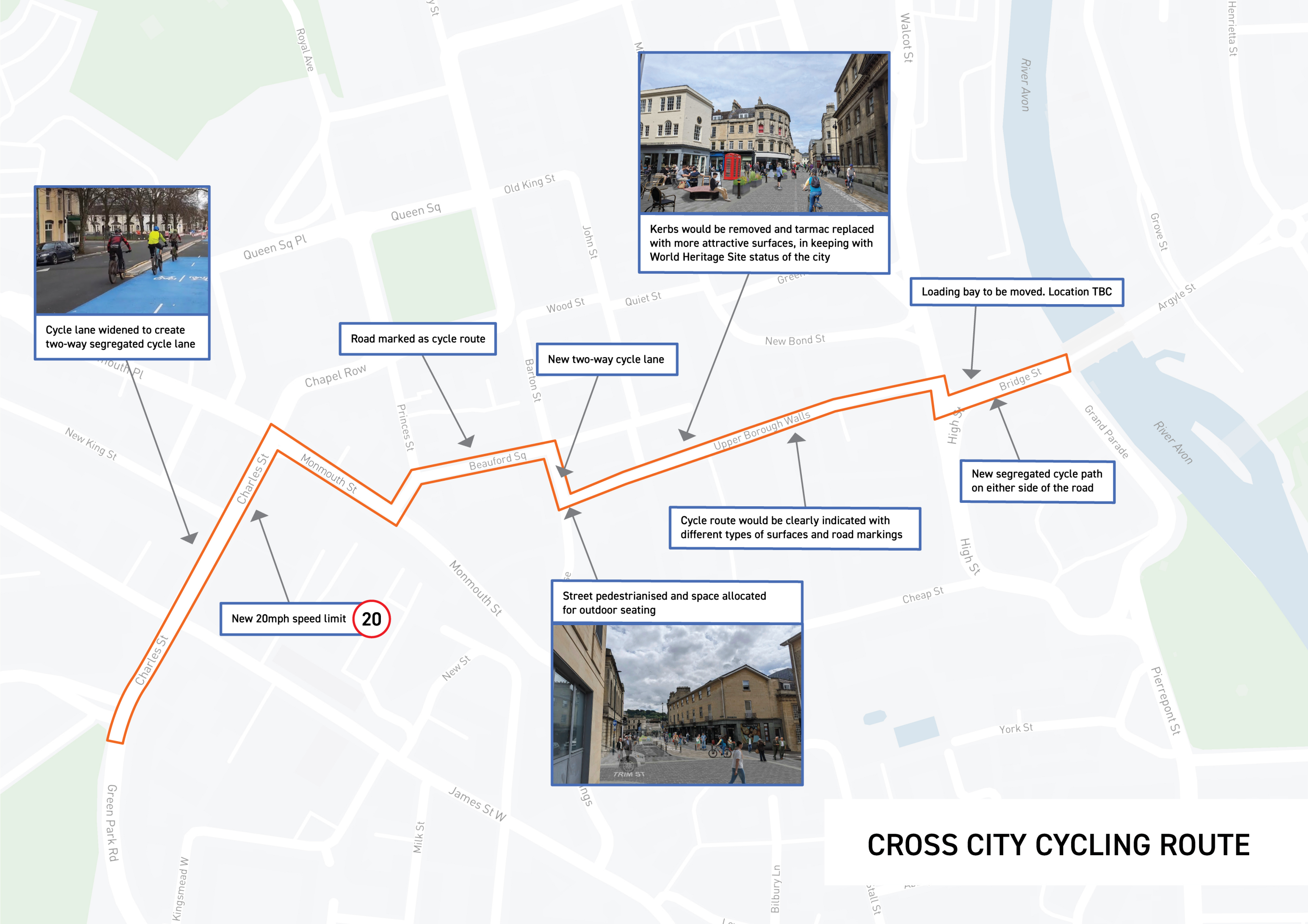
This proposal consists of sections of new and upgraded cycle routes which connect with existing routes and other projects in development.
The Bath city centre part of the long-distance National Cycle Network route 4 - which connects the Kennet and Avon Canal and the Bristol and Bath Railway Path - would be upgraded.
Currently this is poorly signposted and difficult to navigate. At one point it splits into two different routes going east or west, with one taking much longer through the busy shopping streets of Westgate Street and Cheap Street.
The proposals would change this route across the city centre, converting into a single two-way cycle route, running between Pulteney Bridge and New King Street.
A short section of new cycle route further south along Charles Street would plug a 'Missing Link' connecting the existing National Cycle Network route 4 and Upper Bristol Road to the Riverside Park at Bath Quays via Green Park Road. This is part of a different project which will also link across the Bath Quays Bridge to other routes to the south and east.
This would create a better signposted joined-up network across the city centre – making cycling easier, safer and direct. The route would move cyclists away from pedestrians on the busier shopping streets, following mostly along segregated cycle lanes or quieter pedestrianised streets. This would make cycling a more attractive option, appealing to a wide range of people.
Footpaths would also be improved where needed along the route.
We’ve reviewed dozens of different options for how to make travelling through Bath city centre better for cycling - this is our preferred option. We’d like to hear your thoughts; this is your opportunity to comment.
The proposals
From Pulteney Bridge:
The route would run along Bridge Street in new segregated cycle paths either side of the road. To accommodate this, the space allocated to traffic would need to be reduced and the existing loading bay would need to be moved (location TBC).
It would continue in both directions along the Upper Borough Walls (which is currently the route signposted for cyclists heading east through the city). The cycle route would be clearly indicated with different types of surfaces and road markings. Along parts of Upper Borough Walls (including where it crosses the main shopping streets), kerbs would be removed and tarmac replaced with more attractive surfaces. The types of material have not yet been agreed but would be in keeping with the World Heritage Site status of the city.
Move the yellow dot left and right to compare what Upper Borough Walls looks like now, to what it could look like (illustrative only).
At the junction of Upper Borough Walls and Saw Close, the route would turn right into Barton Street. A new section of dedicated two-way cycle lane would be created leading into Beauford Square. Barton Street would become pedestrianised and extra space would be allocated for outdoor seating. This would mean that three on-street parking spaces would need to be removed, but there would still be space allocated for loading.
Move the yellow dot left and right to compare what Barton Street looks like now, to what it could look like (illustrative only).
Continuing along Beauford Square, the road would be marked as a cycle route, before turning into a short stretch of two-way cycle lane in Princes Street.
In Monmouth Street, the existing cycle lane will be made wider to create a two-way segregated cycle lane. There would be no impact on parking. There is also a proposal at this point to remove the right-hand turn from Chapel Row to Monmouth Place to reduce delays from turning traffic.
The route would then turn into Charles Street and continue as a new two-way segregated cycle lane (on the right-hand side of the road heading towards Green Park). It would connect with the National Cycle Network route 4 (Bristol and Bath Railway Path) at the junction of New King Street – which also has recently had a new cycle hangar installed for safe and easy storage. To accommodate this, the road layout of Charles Street would need to be redesigned with one lane in each direction available for traffic, and a 20mph speed limit introduced. The cycle route would continue along Green Park Road towards the Riverside Park and the new Bath Quays Bridge.
What could this mean?
- More direct, safer and easier to navigate the city centre by bike – making cycling a more attractive option for people of all ages and abilities
- Safer for pedestrians by improving some pavements and moving main cycling routes away from the busier shopping streets
- Better onward connections with the national cycling network and local routes
- More in keeping with the historic environment
BUT
- Could result in slightly slower journeys for some traffic
- Small loss of parking – three on-street parking spaces on Barton Street
